click to embiggen
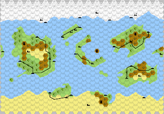
A few months ago Jeff suggested using City States of Arklyrell as a campaign map. I then posted some thoughts on using it as a setting. I found that the images of the map on the internet are a bit hard to make out, so I decided to provide the above map for those wishing to use it.
The "glacier" hexes at the top represent a wall of ice that covers the frozen side of the planet. Any terrain off the map either to the North or the South is completely inhospitable to life (other than Elves in the North and Undead in the South).
I may post more ideas on the setting later.


Very nice!
ReplyDeleteWhat hex scale are you using for the "habitable band?"
ReplyDeleteI think the original premise was that the hexes were only six miles across. That's obviously small, but that's the point of the whole tidally-locked planet thing.
ReplyDelete